9 of the Best Hong Kong Hikes For Intrepid Explorers, Weekend Warriors, & First Timers
I don’t know about you but when it comes to hiking for this Big Body, I’m less of a Nirmal Purja and Tenzing Norgay, and much more of a Preston Blake. You know, that eccentric, pompous billionaire in the Adam Sandler classic Mr. Deeds, who freezes to death while climbing Mount Everest, sans the money, of course.

What might catch you off guard when you travel or move to Hong Kong is that it’s home to a wide range of accessible, scenic, and diverse hikes. One of the driving reasons behind my love for Hong Kong, and why I’ve lived here for over six years (nearly 7), is the proximity to nature and just how darn easy it is to get out on the trails without setting aside your entire day.
I’d press anyone to name a major city in the world where you can access strenuous hikes with breathtaking views, pristine sandy beaches for swimming and surf, and serene parks with temples and vibrant gardens, all within a 15 to 20-minute bus ride (or escalator ride) from the city center.
That’s right, one minute, you can be strapped up in an off-the-rack Marks and Spencer suit and tie shaking hands and signing documents in IFC at 1 PM and atop a mountain, overlooking the world’s most legendary skyline or the beach, by 2 PM.
And, you can still make it back home in time to shower and catch a happy hour in SoHo by 4 PM.
Without further ado, here are 9 of the best hikes in Hong Kong for all you intrepid explorers, weekend fitness warriors, and those trying to sweat out a brutal Iron Ferries hangover – all of which have a completely arbitrary rating out of 10 assigned to them by a man with a beer belly.
Pale Ale Travel Note: I’d be a fool not to include the two most revered authorities on hiking in Hong Kong, (a) Drone & DSLR, and (b) All Trails. As this article does not lay out each hiking route down to every turn and marker, I strongly recommend turning to either of those two resources for logistical planning and route setting so that you don’t end up getting airlifted out of a dense forest after having to eat your father-in-law (for survival).
Tai Mo Shan
Food pics from Duen Kee first followed by Tai Mo Shan pics – just scroll over!
- Where to Start: Duen Kee Tea House or Tsuen Kam Au (near Tai Mo Shan Country Park Visitor Center)
- Length: 10 km to 15 km
- Difficulty: 8.5/10 – pretty damn hard due to a long steep ascent, rugged terrain, and potential difficulty
- All Trails Link
Of the most epic hikes in Hong Kong that I’ve ever done, this currently stands at number 2. You’ll see why the last hike on this list edges this one out. Tai Mo Shan is Hong Kong’s ‘Everest’ – aka it’s Hong Kong’s highest peak.
Located in the heart of the New Territories, in the north of Tai Lam Country Park, this nearly 1,000-meter-high peak is what I’d classify as a “hiker’s hike,” as a straight shot up to the peak is going to be roughly 8 km and round trip 16 km. However, if you get lost, like my fellow trail runners (HOTDOG!) and I did, you could easily see a near-20km day.
Pale Ale Travel Note: The only reason we got lost was because it was an incredibly foggy day and we took a gamble on descending via the unpaved route down to Tai Wo and the Tsuen Wan area.
This is an all-day type of hike where you bust out the Nuun hydration and electrolyte gels, toss on some stretch-fit trekking tights, and tell Nana you’ll be back to feed her soup later. With that being said, it’s also one of the more manageable mountains to hike in Hong Kong thanks to the paved route leading up to the peak from the west and considerably cooler weather (thanks to the altitude).
I personally recommend starting your hike out by grabbing an early breakfast at the famous (and iconic) self-serve dim sum restaurant ‘Duen Kee Tea House’, which sits at the base of Tai Mo Shan, and then making your way up the paved path to the peak, where you’ll see the PLA Weather Radar Station (however, it’s blocked off). From there, make your way down via Sze Fong Shan, Chau Ma Kong, and Kam Shan Road.
The descent down via Sze Fong Shan is the definition of rugged terrain and cluttered with thick vegetation, so make sure to wear long pants, long sleeves, and gloves (if possible). Honestly, if we hadn’t hit up Duen Kee for dim sum before, then I would have preferred to start at Tai Wo, making my way up the mountain in reverse, as (no doubt) it would have been far easier to descend on the paved road.
After completing this hike, we were all absolutely wiped out and I remember rabidly consuming three burgers from Mos Burger before passing out in the taxi back to Tsim Sha Tsui – my head as heavy as when I was a kid after a Kraft mac and cheese cup and my third chocolate milk.
Lamma Island Loop(s)
- Where to Start: Yung Shue Wan Ferry Pier
- Length: 6 km to 12 km (depending on when you decide to loop back)
- Difficulty: 1/10 – very easy and in the realm of a brisk walk (or leisurely walk) thanks to the level ground, numerous bail-off points, and paved paths.
- All Trails Link
Hong Kong’s quirky ‘Bohemian’ outlying refuge, Lamma Island, happens to be home to several picturesque ‘loops’ that fall somewhere between a leisurely stroll and a not-so-strenuous hike. In my humble opinion, they’re best tackled as a little warm-up and sweat before a day at the beach.
My favorite of the various loops you can do on Lamma Island is the relaxed 10 km to 12 km loop, which starts from the main ferry pier in Yung Shue Wan, the most populated area on the island – easily accessible from Central via Ferry Pier 4.
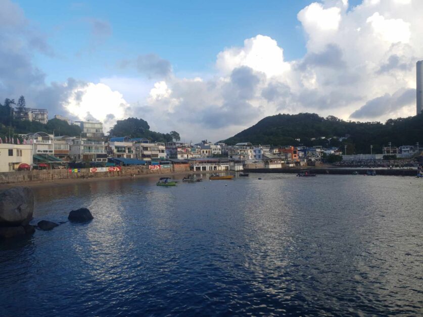
It carves south through old-style village homes, seafood restaurants, and cafes (with fishing boats older than this Big Body all in view), passing by Hung Shing Yeh Beach and Lamma Power Station Beach (both a great spot to circle back to and swim), down to the small fishing village of Sok Kwu Wan.
Consider stopping by the Kamikaze Cave(s) along the way for a glimpse into Hong Kong’s past. These World War 2 era caves were used by the Japanese to hide speed boats that were used for suicide (kamikaze) attacks on Allied warships. However, the war ended before the caves were completed.
Sok Kwu Wan offers scenic viewpoints overlooking the coastline and is a formidable stop for lunch – the Lamma Rainbow Seafood Restaurant is my recommendation. From there, you can retrace your steps and double back, stopping at my go-to, Power Station Beach for a swim (usually tossing back several cans of brew while doing so) – which I’m unsure if is the reason that I glow in the dark at night.
Keep in mind that you can turn back at any point, so this scenic stroll can really be whatever length you want it to be!
Pale Ale Travel Tip: One of my favorite things to do anytime I go out to Lamma after finishing this short loop is to end at ‘Dale Candela’ – a vibrant, no-nonsense Spanish restaurant that serves up ice-cold Estrella drafts and paella. Make sure to time it perfectly so that you’re there for the first or second batch of paella.
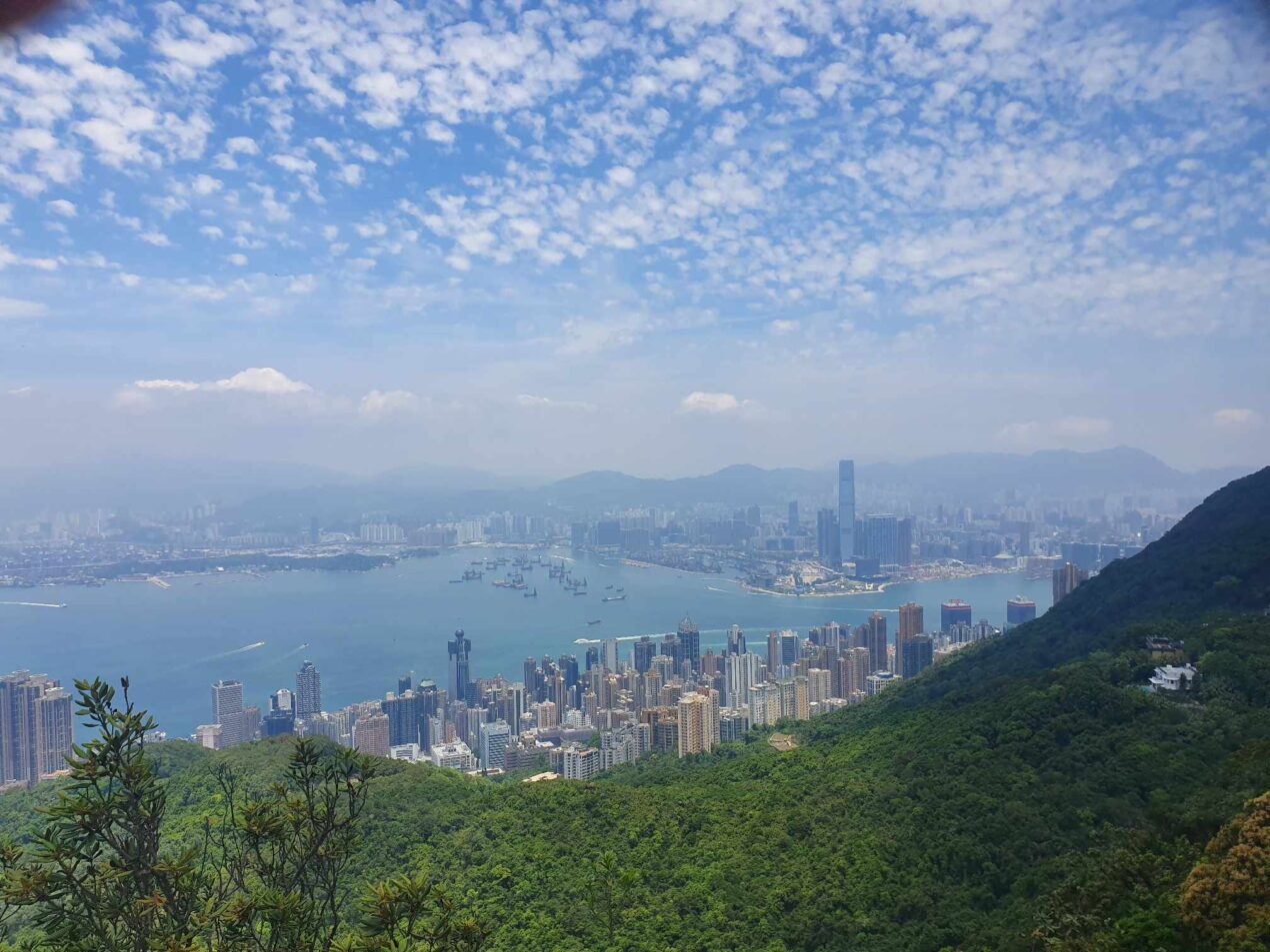
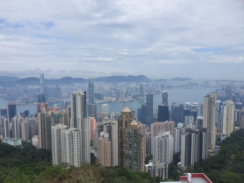
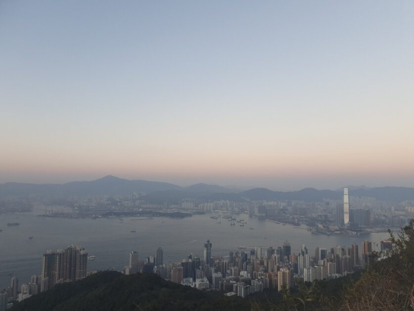
The Peak + High West
- Where to Start: Conduit Road/Hatton Road
- Length: 12 km to 15 km
- Difficulty: 2.5/10 (The Peak), 4.5/10 (The Peak + High West) – you’ll break a sweat going up The Peak but it’s nothing more than a ‘steep walk’. High West isn’t long enough of an ascent to truly put you to the test.
- AllTrails Link (+ High West)
I don’t want to dox myself but I will. You can find me doing this hike almost every single Friday. I’ve been doing this now for nearly four years straight. I do it out of convenience and out of tradition (let me explain). It’s right in my “backyard.”
This currently is and was my go-to hike with one of my top dawgs during the Covid-19 years, as he and I had both moved back to Hong Kong around the same time and realized there was literally no reason for us not to get our bootays off the couch and spend some dawg time together.
This hike can be whatever you want it to be. If you want to keep it shorter, you can simply tackle the Peak Morning Trail, which our record time is 40 minutes from Conduit Road to Burger King (at The Peak), or if you want to stretch it into a proper sweat, you ‘gotsta’ make your way up High West for panoramic views of not only Hong Kong Island and Kowloon (and Victoria Harbour, of course) but the south side of Hong Kong Island as well.
Oh, and there’s Burger King at The Peak, which I know isn’t fine dining but it’s nostalgic. And it’s the perfect mid-way snack or proper meal during the hike. It’s always welcomed on my end but it’s especially welcomed after tackling all 500 meters of High West. Find me a Burger King with a better view in the world and I’ll show you a liar.
All roads lead to Rome when it comes to getting up and down the Peak so know that the hike can be tackled from the north, south, east, and west sides of Hong Kong Island. Above is my favorite route, which I’m now officially declaring ‘The Burger King Trail’.
All in all, a standard ‘Peak hike’ starting on Conduit Road, with a quick pit stop at Burger King and Starbucks (at the top) clocks in at just over 6 km up and 6 km down. When paired with High West, it isn’t particularly that much longer distance-wise, rather timewise you’re looking at an extra 45 minutes or more – depending on if you sit and smell the roses up top.
And by that, I mean taking a breather and looking out over the city and trying to spot dolphins swimming down on the south side.
Pale Ale Travel Pro Hiking Tip: At the top of High West, you’ll see the observation deck that’s marked by railings and ropes. If you peel off to the left when making your way up to the observation deck, you can continue out to a little ledge which is far less crowded and a great spot to take a breather/eat a snack. Be careful and don’t fall!
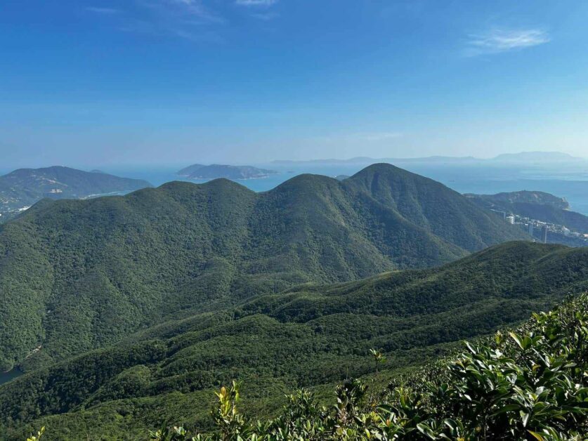
Violet Hill + The ‘Terrible Twins’
- Where to Start: Parkview/Wong Nai Chung Reservoir Park
- Length: 5 km
- Difficulty: 4/10 (Violet Hill), 7.5/10 (Violet Hill + The Twins) – Violet Hill is an easy to lightly moderate hike but combined with The Twins, I’d consider this a contender for the most difficult hike on Hong Kong Island and one that should not be approached lightly.
- AllTrails Link
First, I need to preface that Violet Hill and The Terrible Twins are two separate hikes. I’ve combined them for the purposes of this article as it isn’t uncommon to tackle both in one fell swoop as a full ‘through hike’. Chronologically, Violet Hill precedes The Twins, so let’s address what you can expect getting to (and hiking) Violet Hill.
Now, this isn’t going to be for everyone but if you’re feeling extra adventurous and your T levels are super high that day (this one’s for you Chad!), consider starting the hike well before Violet Hill.
For the dawgz and me, that’s with a hearty brunch at Tai Hang Bar & Grill (don’t forget to snag a banana shake for sustenance!). Now, you might be thinking that I’m sharing this because I love food but no, it’s actually a strategic launching point and the beginning of the hike for us. Post-breakfast, the dawgz and I rip up (hike) to the condominium complex called ‘Parkview’, which the entrance to the Violet Hill trail sits adjacent to.
It’s also a quick 5-minute walk from Wong Nai Chung Reservoir Park.
This tacks on an extra 5 km to the hike. Simply follow Tai Hang Road up or consider even first hiking a portion of Sir Cecil’s and working your way over to Jardine’s Lookout and subsequently, Parkview, the latter taking a bit of finagling and sometimes off-roading. Or, cab up to Parkview. I’ve also done this and it is the approach by the majority of hikers I know.
If you’re in the mood for an easier hike and want to bail off to swim or grab some drinks and snacks down at Stanley or Repulse Bay, I recommend sticking to 430 meter-plus ascent up Violet Hill and peeling off at Tze Kong Bridge towards Stanley Gap Road – after enjoying gorgeous views of the Tai Tam Reservoir (naturally). It can easily be done in sub-2 hours and this 5 km-ish hike will have you working up enough of a sweat to justify several Aperols down by the beach.
If you’re a masochist who wants to feel what it’s like to hike up a never-ending staircase (I’m not exaggerating), then continue through to The Twins. The 1,200 steps up The Twins will have you throwing out that Brazilian butt workout tape once you get home as you simply won’t need it anymore. Prior to my first time hiking The Twins, I went from having a flabby, untoned rear end, to Ms. New Booty 2020’s Runner-Up. Comment below for a snap of me with my sash.
The steps are worth it though once you reach the top of both peaks and are rewarded with views overlooking the Stanley Peninsula, Repulse Bay, Lamma Channel, and beyond. Keep in mind that the first peak of the Terrible Twins is the toughest (in my opinion) and the longest, so the end is somewhat in sight after crossing it off.
This hike is especially near and dear to Big Body as it is usually the hike I do on my birthday. I love nothing more than ending up in Stanley or Repulse Bay for some potent libations with chips and guac. Limewood in Repulse Bay is my go-to and where I recommend to best experience beachfront, sunset views with an Aperol Spritz in one hand and ‘bae’ under the arm.
Pale Ale Travel Tip: I’ve written about several other favorite hikes of mind in my articles breaking down the best Christmas date ideas in Hong Kong and the best (overall) date ideas in the city.
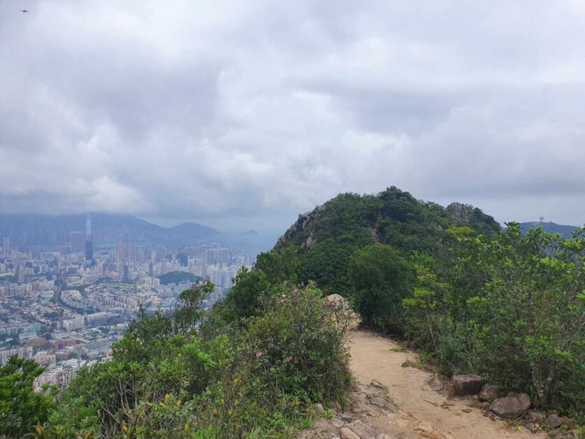
Lion Rock
- Where to Start: Fat Jong Temple in Wong Tai Sin
- Length: 5 km to 7 km
- Difficulty: 7/10 – this bad boy can get steep (especially the final 500-meter ascent to the peak) but is made doable thanks to well-maintained paths and shade.
- AllTrails Link
If you love democracy and fresh air, this hike is for you. If I had to declare any one particular hike, the one that best symbolizes Hong Kong and isn’t just known but beloved by residents, it’s Lion Rock. There’s even a saying called the ‘Lion Rock Spirit’ used to describe the collective ‘can-do’ attitude of Hong Kong’s collective consciousness.
Hong Kong also does have a love of mountains and mountain peaks that are shaped like animals, this 495-meter peak head resembling that of a lion (it’s in the name you bozo).
While it’s not a particularly long hike, and can technically be done in roughly 3 hours (without breaks), it falls somewhere between medium difficult and hard – depending on who you ask. If you ask my Spanish buddy, who may be a reincarnated mountain goat, frequently hiking in cargo shorts and boat shoes, he would classify it as the former. But this Big Body, who may be more representative of the average hiking population in Hong Kong, unequivocally considers it a difficult hike.
Not only does it sport one of the absolute best views of both densely packed Hong Kong Island and Kowloon skyscrapers and housing complexes but it has served as one of the last bastions of democratic defiance and refuge for those who fought the good fight against Hong Kong’s declining rule of law, serving as a popular spot for protestors to hoist pro-democracy signs and wave flashlights and laser pointers.
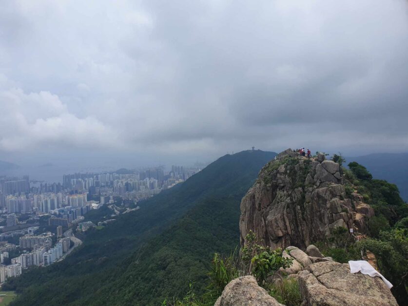
Like The Peak, there are more routes than you can shake a stick at. However, the most popular starting point is from Fat Jong Temple in Wong Tai Sin (exit at Wong Tai Sin MTR exit B3). There’s a rugged yet controlled beauty to this hike thanks to the natural rock formations at Lion Rock’s core, well-maintained paths, shaded segments, and resting points.
From Wong Tai Sin, there are two trails you can take: the first being from Shatin Pass and the second the steps behind the Fung Wong Fresh Water Service Reservoir. Personally, the dawgz and I love getting extra steps in so always opt for the Shatin Pass via MacLehose Trail Section 5 – and it’s more scenic. The latter (Fung Wong) is a straight shot up via a steep incline and is preferable for your descent (as it’s nearly 2 km shorter).
After tackling the demanding final 500-meter hike to the peak, you’re in for a treat thanks to possibly the best bird’s eye view of the urban, concrete jungle that is Hong Kong. Tai Mo Shan is also visible to your back (the first hike on this list). Instagram pictures and selfies soon to commence.
Keep in mind that the exposed summit can pose a bit of a danger in summer months when temperatures get hotter than “H-E Double-Hockey Sticks.”
Pale Ale Travel Tip: On top of access to the beach and nature, there are countless other benefits to living in The Fragrant Harbor. Make sure to check out my post breaking down the pros and cons of living in Hong Kong as an expat.
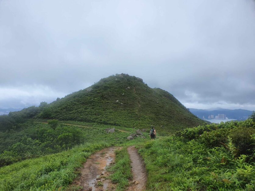
Buffalo Hill
- Where to Start: Wong Nai Tau Bus Terminus
- Length: 7 km
- Difficulty: 8.5/10 – this is a healthy mix of being uncovered, long, and steep. I would not recommend this as a first hike for someone!
- AllTrails Link (Drone & DSLR has a better map/route)
Next to Mui Wo, Tai Mo Shan, and Ap Lei Pai, Buffalo Hill is one of the most memorable hikes for this Big Body and one of my favorites in all of Hong Kong. That’s probably because it’s one of the most strenuous on the list. Some might say you need the actual sturdiness and grit of a buffalo to tackle this hike. Others might say “Hey you weirdo, just shut up and write this article without all the commentary.”
I digress.
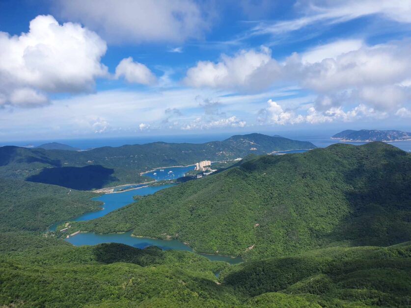
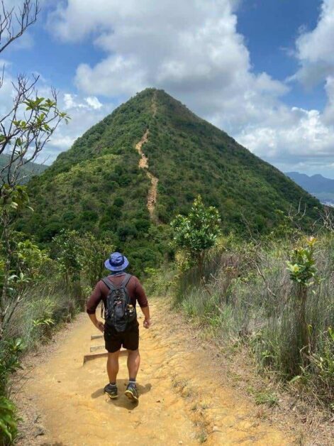
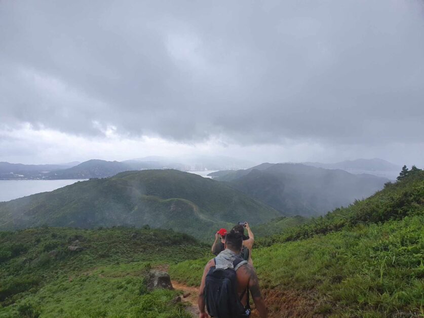
Buffalo Hill, is aptly named as the head peak looks like, you guessed it, a buffalo. Expect nearly 2,000 feet of elevation on this lesser-known scenic peak located out in the Ma On Shan Country Park. What I love about Buffalo Hill is that it has it all. Grassy hills, rugged landscapes, panoramic views, and a finish point down by the water. It’s also a far less trekked mountain than say Lion Rock so there’s a good chance, depending on the day, you might not even see anyone.
Beginning at the Wong Nai Tau Bus Terminus in Shatin, you’ll make your way through a forested path that gradually opens up to reveal expansive grassy hills. The trail up is moderately steep and takes you through to West Buffalo Hill first (which caused me great confusion when I was first planning on doing this hike). From the top of West Buffalo Hill, you’ll enjoy sweeping panorama views of the Sai Kung Peninsula, rolling green hills and dense forests of Ma On Shan Country Park, and the surrounding coastal islands.
From there, you’ll channel your inner bison and push through to Buffalo Hill itself, which involves a steep but manageable climb to the peak. This peak is on the more rugged side but the 360-degree views of Ma On Shan, Kowloon, and even Shenzhen (on a clear day) make it somewhere you can comfortably hang out and recuperate.
While you can double back the same way you came, I recommend descending via the Buffalo Pass towards Sam Fai Tin and subsequently Hebe Haven (Pak Sha Wan). Look, I’ll be honest, this second leg of it can feel like it’s taking years but this is where legends are made. Unfortunately, the revered Padstow Restaurant in Hebe Haven has since shut down but there are a handful of restaurants to post up and grab a bite/recap with a beer at.
All in all, the hike comes in at just over 7 km. But this isn’t a casual, ‘cool guy’ Fonzarelli 7 km that you can whip through with ease, it’s sustained incline and climbs that can take upwards of 4-plus hours, depending on how many breaks you take.
I’d like to give a shoutout to F-dawg. There’s something to be said about the camaraderie that’s forged when you’re hiking a difficult mountain with a friend. It’s something that I cherish and think we don’t get enough of as we get older. Buffalo Hill was one of those hikes for me as I did it with one of my best dawgs, who understood I was entering catastrophization mode at several points during the hike – especially when it started raining and thundering.
I firmly believe because of my more rotund stature (some might say the stature of a buffalo) that I’m the perfect object for lightning to strike should Zeus feel extra feisty that day.
Pale Ale Travel Note: I know this isn’t material to the hike at all but I do want to shed a little light on one of the most beautiful linguistic constructs in the English language, this grammatically correct sentence, “Buffalo buffalo Buffalo buffalo buffalo buffalo Buffalo buffalo.” I recommend reading a little bit about it here if you want a good chuckle for the day.
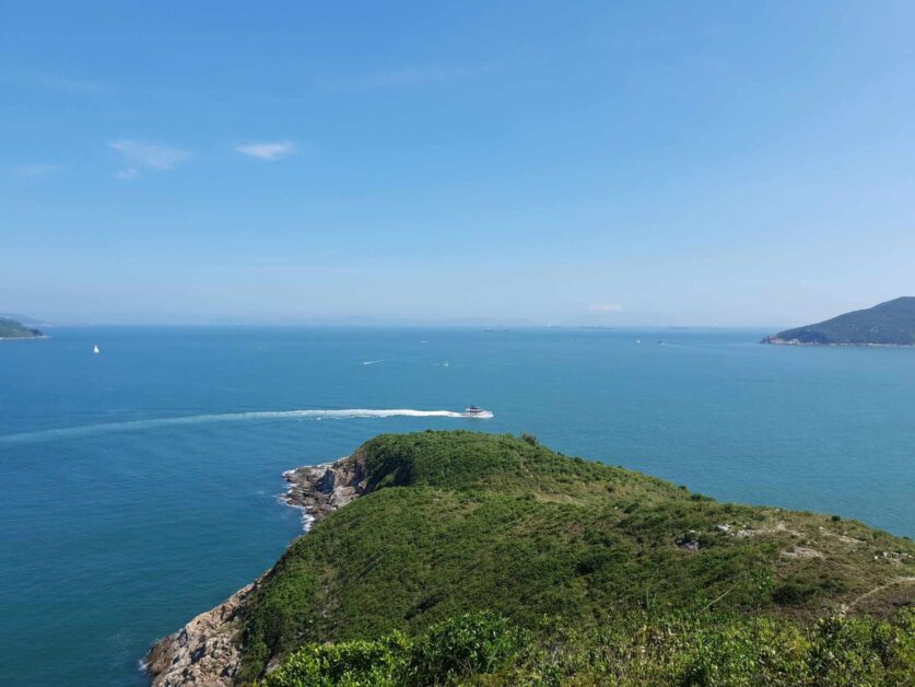
Ap Lei Pai
- Where to Start: Lei Tung MTR Exit B in Ap Lei Chau (near the McDonald’s)
- Length: 5 km (maximum)
- Difficulty: 6.5/10 – Mount Johnston can be treacherous when ascending and descending. Add on absolutely zero bailout points and the entire hike being uncovered and it’s on the more difficult side/can catch you by surprise if you don’t prepare accordingly.
- AllTrails Link
I genuinely feel that the south side of Hong Kong doesn’t get enough love. Aberdeen was, after all, the first place the name ‘Hong Kong’ was used, so let’s swing on down and see what’s in store for us down on Ap Lei Chau (besides floating seafood restaurants serving up “typhoon shelter crab”).
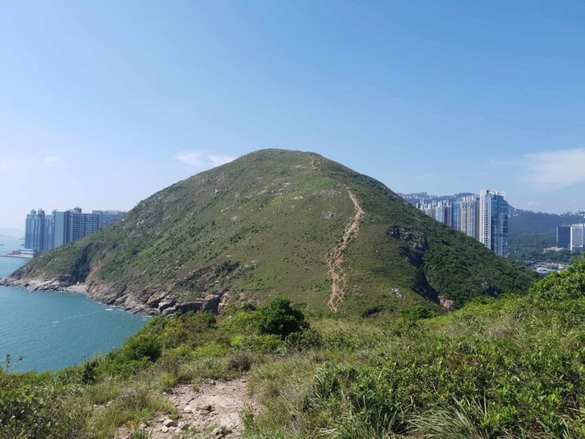
What a peculiar, wild, and fulfilling hike Ap Lei Pai is. The quirky tone of the hike is set immediately with the trail’s hidden entrance behind two yellow booths at the Lei Tung Estate. Power through them and you’ll stumble upon a path that will lead you to steps up Mount Johnston.
There is no loop with this one. It’s straight out to a small uninhabited island (Ap Lei Pai) via Mount Johnston and a connecting narrow sandbar, returning the same way you came.
In total, the hike is no more than 5 km but it’s a 5 km that you’re really going to have to work for.
The crux of the hiking occurs during your initial ascent and descent of the uncovered Mount Johnston, aka Yuk Kwai Shan, a nearly 200-meter tall mountain with both an incline and decline so steep the inventor of the StairMaster would question his/her own existence. Also, it turns out that three people were actually behind the StairMaster’s birth.
There are even set ropes to assist with the ascent and descent, so make sure to mentally prepare for this. Also, packing a pair of gloves is recommended to avoid rope burn and mitigate the damage to your hands.
Once you make it down Mount Johnston, after enjoying the sprawling ocean views of Lamma Island, your trek out to Ap Lei Pai and its lighthouse is a breeze – taking no more than 20 minutes. Ap Lei Pai doesn’t have the clearest of paths so you will need to work your way through some bushes on your hike out to the rocky cliffs facing the Mount Johnston Lighthouse.
There’s a hidden natural tidepool to the right of the lighthouse which I recommend taking a dip in!
My word of caution for this hike is that there is NO bail-out point AT ALL, as you hike straight out to a little island and your only way back is the way you came. This is something to consider in the dead of a Hong Kong summer, which can see temperatures reach nearly 40 degrees Celsius.
In fact, when I hiked this with two of my top dawgz, we made the unfortunate mistake of doing so on a 38-degree summer day and with minimal water supplies. It was legitimately dangerous as the only way back was back up Mount Johnston or water tracing along the cliffs (which there are set ropes to do so) to take a somewhat circumlocutory route back.
But for an angel on her sampan (a small houseboat) that was passing by the island, who offered to shuttle us back to Ap Lei Chau for roughly HK$10 each, we would have been up a certain creek without a paddle or the newest (and only) inhabitants of Ap Lei Pai.
So, keep an eye out for the sampans that offer their services back to Aberdeen Pier, as it may just save your life! If I remember correctly, the last one runs at 6:30-ish.
Needle Hill
- Where to Start: Lei Muk Shue Estate (Shing Mun Reservoir)
- Length: 8 km
- Difficulty: 6.5/10 in winter and 9/10 in summer due to the fact the majority of the ascents are covered and lack of bail-out points.
- AllTrails Link
Needle Hill may be the most deceiving hike on this list due to roughly ¾ of this 8 km route being almost entirely uncovered. In my opinion, this also makes it the most dangerous, especially during the dog days of summer.
This is a mountain in Hong Kong that I would describe as ‘surprisingly steep’. The most popular (and steepest) route starts from the Shing Mun Reservoir’s Lei Muk Shue Estate, between Tsuen Wan and Shatin. This is best accessed via the Kwai Fong MTR.
Beginning at Lei Muk Shue Estate is my recommended approach thanks to the views of the Shing Mun Reservoir and dam on your ascent and incredible views of Ma On Shan, Shatin, Lion Rock Country Park, and Ma On Shan Country Park on the descent.
Needle Hill is really three distinct peaks all masquerading as a single mountain, with both the first and second segments (aka miniature peaks) leveling out – making for great spots to rehydrate and collect yourself. The beginning of the hike is also the only real time you’ll have any sort of shade to protect you!
The second segment is really where you need to pace yourself and not expend any more energy than you have to, as the third and actual ascent up Needle Hill will inevitably put you to the test. Psychologically, it’s a bit daunting staring up at an exposed yet well-defined 400-meter dirt path to the top. But, I think this is better than a hike where you can’t tell exactly where you’re at on the mountain.
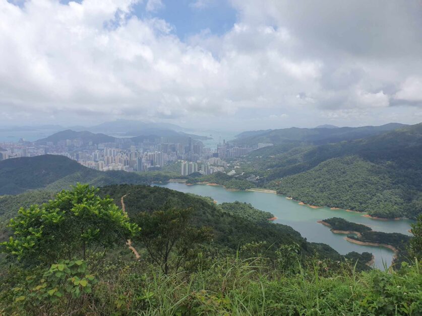
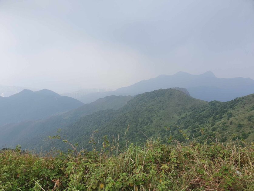
530-plus meters up, at the top of Needle Hill, you’ll be welcomed with stunning 360-degree views of nearly every inch of Hong Kong, including several hikes on this list (Lion Rock, Tai Mo Shan, and Buffalo Hill) – you can even see the ICC and Hong Kong Island on a clear day.
Continue down via Maclehose Trail Section 7 to Shatin and enjoy the picturesque views of rolling hills and surrounding mountains. Something about the view when going down was especially beautiful on that hot hot day, as deep down I knew that shade was soon to be in my future. This is also where you’ll encounter paved roads of the Shing Mun Reservoir Forest Track, which lead you to a dirt trail and stone steps to take you into Shatin.
A Word of Warning About Needle Hill
While this was one of the most fulfilling and challenging hikes I’ve ever done with the dawgz, it was also the only one that I’ve ever had to take a minute, slow down, and recognize that I was in danger if I didn’t start hydrating properly.
I started to get that throbbing headache you get in the early stages of extreme dehydration. It was 38 degrees and extremely humid, and I was straight up unable to retain water on this hike.
I had nearly gone through my entire 10 liters of water before popping some Nuun electrolyte tablets into one of them and finally feeling as if I wasn’t going to pass out.
What I strongly recommend for a hike like this is to make sure that you show up stacked to the gills with electrolyte tablets and powders (or traditional electrolyte drinks) and a hat.
Tiger’s Head (Mui Wo to Discovery Bay)
- Where to Start: Mui Wo Ferry Pier
- Length: 10 km
- Difficulty: 7/10 – due to the rugged terrain, poor footing on the descent, and length.
- AllTrails Link (Drone & DSLR has a better map/route)
Honestly, I had to save the best for last. It’s not even that Tiger’s Head is what I consider to be the most scenic or strenuous hike in all of Hong Kong but there’s a history to this trail for me. And that puts it at the top of my list when it comes to my favorite hiking trails in Hong Kong.
One of my best friends unfortunately moved out of Hong Kong several years ago. In the lead-up to his departure, the dawgz would schedule Friday or Saturday hikes like clockwork, where we’d spend quality time, reward ourselves with a few beers, and consume more steaks and plates of nachos than a Texan NASCAR fan.
One weekend, with a typhoon fast approaching Hong Kong, we decided to burn some calories before a night of gourmandizing. At this point in our Hong Kong tenures, we were a bit disenchanted with the Hong Kong Observatory and their typhoon predictions, chalking this one up to be hogwash and likely nothing but a light rainstorm.
Well, we were completely wrong.
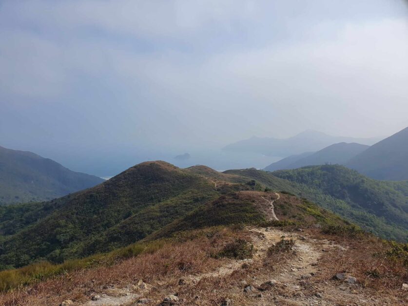
A perfectly sunny day on the ferry ride over to Mui Wo (Lantau Island) quickly turned into a ‘Typhoon 8’, but only after we had made it halfway through the hike. Minus the blustering winds, torrential downpours, and sand whipping against our shirtless bodies on that fateful day, the 10 km Tiger’s Head route on the Lo Fu Tau Country Trail is relatively straightforward. Challenging but straightforward.
Simply take the ferry from Central Pier 6 to Mui Wo, which plops you down right along the Mui Wo Ferry Pier and will see you weave your way through classic Lantau village houses and farms, lush greenery, and the Silvermine Waterfall (and Silvermine Cave). Post-waterfall/cave is when the hike really kicks into gear when you rip up the Hong Kong Olympic Trail to the Mong To Au Shelter Pavilion and then hop onto the Lo Fu Tau Country Trail.
Once on the Lo Fu Tau Country Trail, you’ll encounter a doable, gradual incline, with occasional steep stretches. Nothing you haven’t seen before. After putting in some arduous steps, the trail will open up to a view I bet you weren’t expecting – the lush golf course of the Discovery Bay Golf Club.
However, the views of pristine greens and hoity-toity bankers soon turn to stone, with a stretch of boulders and rocks defining the next stretch – all before you make your way up the uncovered 465-meter tall peak of Lo Fu Tau (Tiger’s Head) for unobstructed, panoramic views of Discovery Bay, Tuen Mun, Castle Peak, and even Hong Kong Island (on an extremely clear day).
Make sure to keep an eye out for planes taking and landing off at the nearby Hong Kong Airport.
And yes, Lo Fu Tau does resemble a tiger’s head. Hence, the name.
I recommend approaching this hike the same route the dawgz and I did, from Mui Wo to Discovery Bay Plaza, as tackling it in reverse can yield a precarious ascent up Lo Fu Tau (Tiger’s Head), one that is rife with loose rocks, gravel, and uneasy footing – even descending is a bit of a zugzwang and led to both my top dawg and I falling and injuring ourselves.
Pale Ale Travel Tip: Should you follow the route from Mui Wo to Discovery Bay (and not the other way around), consider hitting up one of the several restaurants along the Discovery Bay Ferry Pier (RIP to Moofish by Zaks) – a legend in the game serving up Corona daiquiris that were as big as my head).
Hut, Hut, Hike!
A fantastic sign out on Mui Wo before hiking Tiger’s Head.
Before you get out on the trail, I have a few words of wisdom – which were learned the hard way, unfortunately.
Tackle the most difficult hikes from October to March/April-ish for the most manageable weather, load up on water and sports drinks before you hike (even more than you think you’ll need), always (if possible) hike with a buddy and/or group, bring electrolyte tablets or gels, wear a hat or bring some sort of covering (sometimes I use an impromptu rag), and make sure that you have proper hiking shoes.
Learn to recognize the signs of dehydration. If you start feeling ill and your head starts throbbing, slow down and seek shade. It’s time to hydrate. This city doesn’t mess around when it comes to temperatures and humidity that will leave you feeling depleted of every ounce of energy and hope.
And don’t be afraid to turn back. Some days it just isn’t in the cards due to the weather and that’s completely alright. After all, summer is almost completely un-hikable due to the steep temperatures and humidity.
If you have any favorite hikes in Hong Kong or any questions about getting to a hike, please don’t hesitate to reach out to me in the comments or via email (info@palealetravel.com).
Happy hiking everyone,
Big Body
Big Body is a voracious lov…eater, a cowardly fighter, and a self-proclaimed curry goat BBQ-eating champion (don’t forget the donkey milk) who likes Stoicism, baseball, and writing in the third person. Having worked for himself for the last 7 years, he isn’t particularly successful but he does still drink ice-cold Sapporo draft beers with the best of them and knows his way around a Dai Pai Dong or two. He is based in Hong Kong but you can still find him in Saigon, Osaka, and Vienna for extended periods.